GPS Utility 5.17 Details
Shareware 1.98 MB
Publisher Description
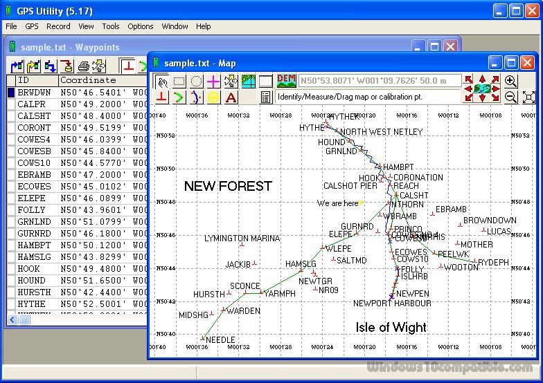
 Software for managing and mapping GPS information (waypoints, routes and tracks). Use it for transferring data between GPS receivers and many other software applications. GPS Utility also contains many useful analysis and data manipulation tools. It is particularly useful for dealing with data in different file formats, datums and grid coordinate systems. Visualise your GPS data over a background map before exporting to Google Earth. Prepare your GPS routes and waypoints before uploading to your GPS receiver.
Download and use it now: GPS Utility
Related Programs
UTM Coordinate Converter
UTM Coordinate Converter, converts between various geographic coordinate systems, allowing you to convert between various Latitude/Longitudes systems and the Universal Transverse Mercator (UTM) system. It includes a map that displays the location you converter, as well the map allows to...
- Freeware
- 20 Jul 2015
- 61.96 MB
NOV Grid for .NET
NOV Grid for .NET is a high performance Data Grid component for displaying and editing tabular data within your WinForms, WPF, Silverlight, MonoMac and Xamarin.Mac applications. The NOV Grid for .NET framework includes a TableGrid and a TreeGrid (ListTreeView) controls...
- Shareware
- 01 Jul 2016
- 307.34 MB
.Net Grid
The grid was initially designed for electronic financial markets with their stringent requirements to robustness, low consumption of memory and CPU resources, ergonomic and simple user interface and rich API. These requirements share a common objective - to gain the...
- Shareware
- 29 Sep 2016
- 25.47 MB
Photo Grid for Facebook
Create an interactive photo grid and share it on Facebook Key features: - Enlarge each photo with an animation effect - Add photos from Facebook or upload your photos - Easily post your photo grid on Facebook - Browse 1000's...
- Freeware
- 20 Jul 2015
- 21 KB